Our Curious Coast: The Ocean and Coastline
Simply taking a walk along one of North Carolina’s beaches is enough to show how shifting its sand truly is.
As the fine grains shuffle between your toes, get pushed around in the surf, and are whisked away by the winds, it’s easy to see that they rarely stay in one place.
Continuing our blog series about the Coastal Plain, today’s post focuses on where the land meets the water, how this boundary has moved in the past, and what the perpetual motion of the ocean could mean for coastal communities in the future.
Active Ocean Currents
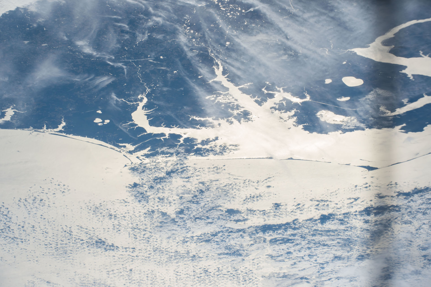
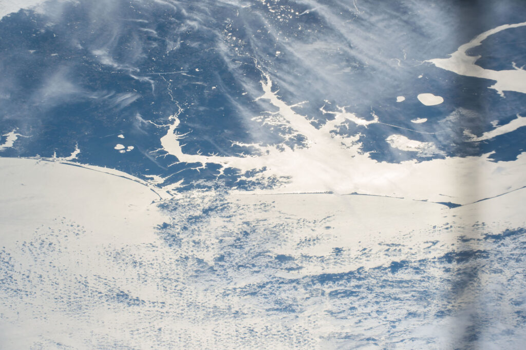
It may look like a uniform deep blue sea, but the waters off our coast are anything but homogeneous. In fact, they feature a diverse mixture of ocean currents vying for position from north to south, east to west, and from the surface down through the depths.
Just like our state is a battleground for barbecue, with different preferences and sauce styles originating from their eastern or Lexington-style roots, our offshore ocean offers a buffet of water from different sources.
“There’s a confluence of shelf waters off of our coast,” said Dr. Mike Muglia, an assistant scientist at the Coastal Studies Institute and a research assistant professor in the Department of Coastal Studies at East Carolina University.
Warm water originating from the recessed part of the East Coast in Georgia and northern Florida, known as the South Atlantic Bight, flows past Cape Fear and Cape Lookout on its way to the north. Meanwhile, cooler water from the coasts of Maryland and New Jersey – another curve in the landscape called the Mid-Atlantic Bight – heads southward, and the two streams of shelf water play a tug-of-war usually contested just off Cape Hatteras.
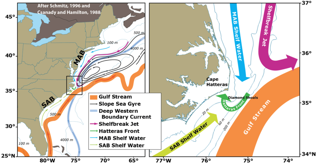
Their opposing origins are obvious not only from the temperature of the water, but also what’s living in it. Muglia said Maine lobsters have been caught off our northern coast near Kill Devil Hills, while Florida lobsters have been caught near Wilmington.
There is another, better-known player in this oceanographic onslaught as well. The Gulf Stream is a fast-moving, warm, and salty current that circles the Gulf of Mexico and heads up the East Coast. It generally hugs our southern coastline before heading out to sea.
These currents converge at the Hatteras Front, and along this boundary, you’re likely to find a feeding frenzy.
“This is a great place for fishermen,” said Muglia. “They catch tuna, marlin, and many other fish.”
Some maps also depict the cold Labrador Current diving southward from its Canadian home and extending all the way down to North Carolina, but Muglia dispels that myth.
“It makes me wince when people say the Labrador Current slides under the Gulf Stream,” he said, noting that instead, cool but much deeper water reaches our coast via the Deep Western Boundary Current.
Some of that water making its way to the North Carolina coast does originate in the Labrador Sea, but as the current’s name implies, it typically remains far beneath the ocean’s surface, meaning the cooler water at our northern beaches hasn’t really reached us all the way from the frigid Arctic. Its origin is closer to Atlantic City than the North Atlantic.
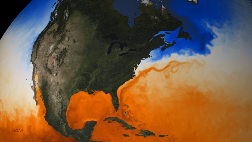
Although it may not directly intersect with our coast, the Deep Western Boundary Current is still an important piece of the overall ocean system, distributing heat throughout the Northern Hemisphere as part of the Atlantic Meridional Overturning Circulation, or AMOC.
As sea ice melts and the ocean surface gets less salty and less dense, the conveyor belt of the AMOC won’t be as effective at distributing water from the shallows through the depths of the Atlantic.
The Intergovernmental Panel on Climate Change suggests it’s very likely that the AMOC will weaken during this century, although by 2100 it’s unlikely to reach a tipping point that might cause the Gulf Stream to shut down altogether.
There are different theories about the future of the Gulf Stream and its sensitivity to climate change, with limited consensus among scientists at the moment. However, it is a reminder of the dynamic nature of our offshore waters and their importance to the nearby land we call home.
The Ethereal Outer Banks
We don’t have to wait a century to see changes happening along our coast. In fact, it’s constantly changing, albeit at a much smaller magnitude, due to the toll of winds and waves chipping away bits of our beaches, and from the giant bites that storms occasionally take out of the land.
When we talk about what’s happening along our state’s eastern extent, it’s important to clarify exactly what defines this boundary between land and water.
Dr. Joe Long is an associate professor of coastal processes and engineering at UNC Wilmington who studies the physical processes that shape our coast. He notes that two terms we often use interchangeably have slightly different meanings in the context of the changing landscape.
The coastline, he said, refers generally to the broad coastal region where the land interacts with the water. This can include areas that sometimes experience storm surge or saltwater intrusion, but otherwise may not normally touch the ocean.
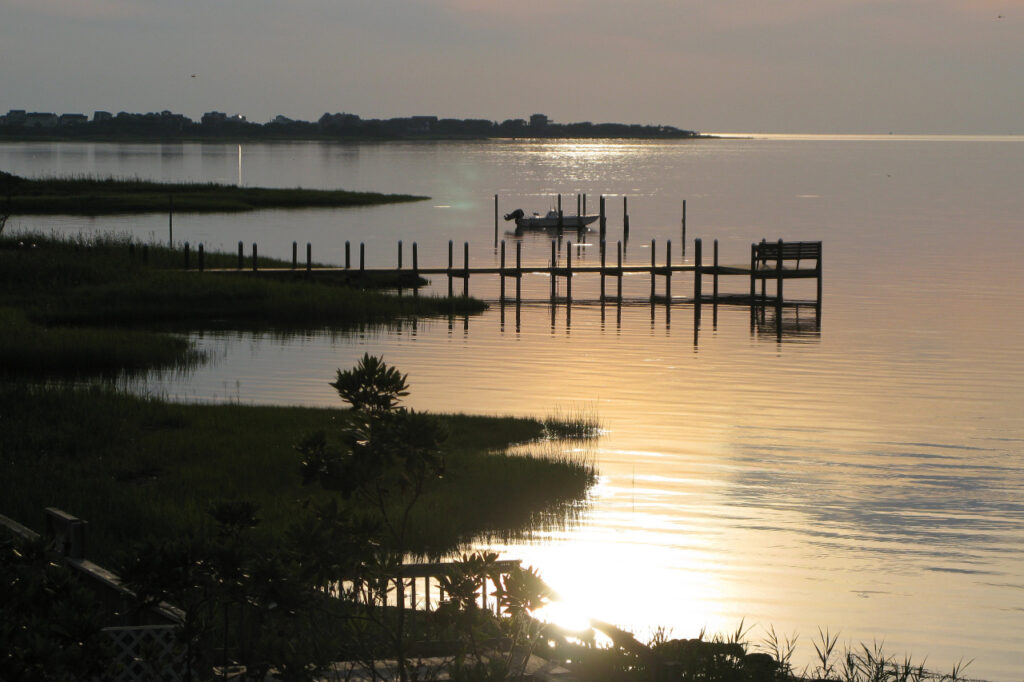
The shoreline is more specifically the intersection between water and land, which changes daily due to tides, winds, and weather.
Even by the more general definition, North Carolina is undoubtedly advanced.
“We have one of the most complex configurations of coastlines anywhere in the eastern US,” said Long.
In our previous post, we described the geological history of the Coastal Plain, from the greatest inland extent of the coastline – to what we now call the fall line – almost three million years ago, through the decline of sea levels since then, including the eventual uncovering of current parts of eastern North Carolina after the last interglacial period around 125,000 years ago.
Our dynamic coastline has shifted plenty since then, too, and we still see those trends continuing today. Centuries ago, the land extended even farther into the Atlantic, with wider beaches and dunes.
“People don’t quite realize that our original coastline was 50 to 100 kilometers east of us, and it has moved this way in a couple thousand years,” said Dr. Shannon Klotsko, assistant professor of geology at UNC Wilmington.
Another big change over that time was the formation of our sounds, which are geologically young features. Klotsko said those areas were once river valleys that have filled in with water as sea levels have risen within the past 4,000 to 5,000 years.
The sounds are now separated from the broader ocean by the Outer Banks – barrier islands made up of accumulated sand, pushed to its current location by the continuous force of the currents and shelf waters.
But even that location is changing, as Klotsko describes.
“Our barrier islands are naturally trying to roll back,” she said. “From the fact that you have a lot of overwash, the islands are migrating landward.”
That process, called barrier island rollover, is exacerbated by storms that erode the ocean-facing side of the islands and deposit sand and sediment on the soundside. Over time, it is causing the Outer Banks to creep closer to the mainland, and we can see that process playing out before our eyes today.
The Role of Wind and Waves
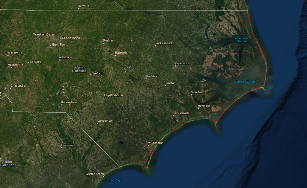
To understand how our shoreline is shifting, scientists have measured and mapped its position over the years. The latest set of erosion rates as of 2020 are available on a map from the NC Division of Coastal Management.
They show areas of erosion – where land is being overtaken by water – in red, and areas of accretion – where new land is forming – in green. Along North Carolina’s ocean-facing coastline, the reds are clearly winning.
Particularly across the northern and central Outer Banks, including on most of Hatteras Island, sand is being sheared away by the northeasterly current, then pushed southward, where it accretes on the south end of the island. The same thing happens to a lesser extent along Ocracoke Island, Cape Lookout, and Topsail Island.
While this constant erosion is slowly but steadily scouring most of our beaches, other processes also affect their shapes and profiles over the course of days, months, and years.
Each day, the typical difference between the water height during low and high tides is about three feet in North Carolina. That’s compared to a tidal range of up to eight feet in Georgia, where during high tide, the water tends to pile up along the curved coastline of the South Atlantic Bight.
Over the course of a year, our beaches are wider in the summer and narrower in the winter. That’s due to generally stronger winds and waves during the winter that cause additional erosion.
The real wildcards for our beaches are storms, both tropical and extratropical. These can cause some of the most dramatic and destructive changes to our shoreline.
“What the beach builds over the course of five years, a storm can change in hours or a day,” said Long. “Storms have a huge impact on narrowing our beaches and redistributing sediment in large amounts over a short period.”
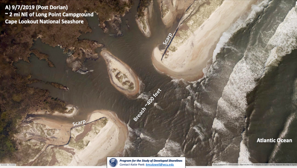
Our three landfalling hurricanes in the past four years have all caused substantial damage to parts of our coastline. Along with its extensive inland flooding, Florence in 2018 created overwash on Masonboro Island north of Wilmington. The next year, Dorian breached parts of Cape Lookout National Seashore. And in 2020, a six-foot storm surge from Hurricane Isaias toppled the dunes – and endangered loggerhead sea turtle nests – on Oak Island.
Also within recent memory, Hurricane Isabel carved a new inlet through Hatteras Island in 2003, cutting off its southernmost town from the mainland for more than two months until it was filled with sand and the section of Highway 12 running across it was rebuilt.
Long said that without human intervention, such inlets sometimes naturally refill over time, while others become permanent. He pointed to Dauphin Island, AL, where Hurricane Ivan cut a narrow inlet in 2004 that was widened by Katrina the next year.
“It was weakened by one storm and taken advantage of by the next, and it would have taken many years for that to close,” said Long.
But some of our beaches may not have that long to recover, as the combination of natural rollover and sea level rise driven by climate change is pushing them back beneath the water that surrounds them.
Emerging Risks at the Shoreline
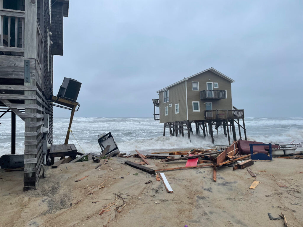
This spring, a pair of homes in Rodanthe on northern Hatteras Island collapsed into the ocean. When they were first built in the 1980s, they were more than 400 feet from the shoreline, according to data from the NC Division of Coastal Management, and protected by a vegetated duneline. Today, they’re nothing but rubble: victims of the ever-encroaching sea.
“What used to be beachfront homes are now in the ocean, and what used to be on 3rd and 4th Avenue are now beachfront homes,” said Klotsko. “It’s going to be a fight between nature and humans, and everything wants to shift inland.”
One weapon in our fight against nature’s inevitable push is beach renourishment, which typically means dredging sand from offshore and depositing it onto beaches to replace part of what has been eroded. But at best, those efforts are just buying us more time, rather than permanently saving those oceanfront properties.
Our other opponents in the effort to preserve our beaches as they appear now are climate change and sea level rise. Melting glaciers and the thermal expansion of seawater as it warms are raising ocean levels at an accelerating rate.
The Wilmington area has already seen a rise of about 11 inches since 1950, and that rate of rise is nearly twice as high along our northern coast due to its flatter topography – remember the lay of the land east of the Suffolk Scarp – and sinking sediments, according to Dr. Reide Corbett, executive director of the Coastal Studies Institute.
For Corbett, the problem goes beyond just houses disappearing into the waves. He also worries about how our coastal infrastructure can withstand these changes, from the need to raise and rebuild roads to managing wastewater disposal.
“Those are things we need to think about,” he said. “Reporters love to show houses falling into the ocean because it’s an attention grabber, but showing a failing septic system isn’t as flashy.”
While the ongoing assault of the ocean along our shifting shoreline is rightfully concerning for many, the very processes behind those changes are an area of clean-energy opportunity for some.
In recent years, offshore wind farms have been proposed and often maligned in a not-in-my-backyard sense, although a recently announced bipartisan initiative will seek to coordinate and expand the industry from North Carolina through Maine.
While such large-scale investments in renewable energy are important, Muglia’s research suggests we could get some of those benefits while keeping them totally out of sight from coastal residents – by harnessing the power of the ocean currents.
His team at the Coastal Studies Institute, together with the Control and Optimization for Renewables and Energy Efficiency (CORE) Lab at NC State University, has been testing devices akin to underwater kites that use the pull of the current to tension a tether. Some of that energy can then be captured, and could be stored as a renewable energy source. For now, it is being used to power measuring devices as part of the research equipment.
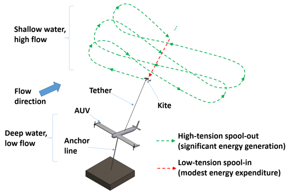
After a successful test being towed behind a boat in Lake Norman, the team hopes to pilot their kite in an ocean environment later this year.
The oceans may also offer a solution to a problem they’re creating: saltwater intrusion into groundwater supplies.
“We just deployed four wave-powered desalination plants to make clean water available on the coast,” said Muglia.
It’s all part of “a big push for powering the ‘blue economy’,” he said, referring to the sustainable use of ocean resources for economic growth, improved livelihoods and jobs, and ocean ecosystem health, as defined by the World Bank.
Of course, these efforts aren’t forever fixes for constantly changing coastal communities, and it will take more than just a few seafaring kites to reverse climate changes or slow the charge of Mother Nature.
But ironically, the ongoing, intensifying wave of water that has shaped our coastline historically and threatens it today could offer the rest of our state hope of a cleaner future.